Monday, August 18, 2014

Isolated at Isolation...No Really

 Sad story. I moved back to Vermont today. I've been packing, unpacking, cleaning, and organizing for HOURRRSSSSS. Literally. I need a break.

Enter my hike on Thursday. I woke up after Wednesday night's storm to gray clouds playing tug of war with peeks of blue sky. I decided to cheer on the blue parts through action and headed up the Kanc towards Glen Ellis Falls on Route 16 in Jackson. I found some really awesome jams on a pop station as I made my way northeast. I was rocking out so hard, getting jazzed for the hike, that a guy on his bike got a good chuckle. The plan was to hike Isolation up the Glen Boulder Trail/Davis Path, run back down and then venture across to bag Wildcat D. I mean, time is dwindling if I'm to get all 48 by the end of the year.

The signage for getting on the Glen Boulder Trail is very clear. You head straight from the parking lot, not turning left towards Glen Ellis Falls, but instead towards the toilets until you spot this lovely sign. It'll point you in the right direction (and only 1.6 miles to the boulder? sweeeet!)


The trail was expectedly wet and muddy after the monsoon that stormed through. There were rocks to galavant across like stepping stones guiding you along. I got distracted by a giant toad jumping around until he hid in a hole. While I was chasing him I heard the tinkling of water that signaled a waterfall. Therefore, I proceeded to this gem.
Then I wondered what happened to the trail because there was no way I was going to be able to scale the muddy hill that was in front of me. So I did the reasonable thing and backtracked to where I saw the toad. That's when I noticed the markers were on the rocks. Duh.

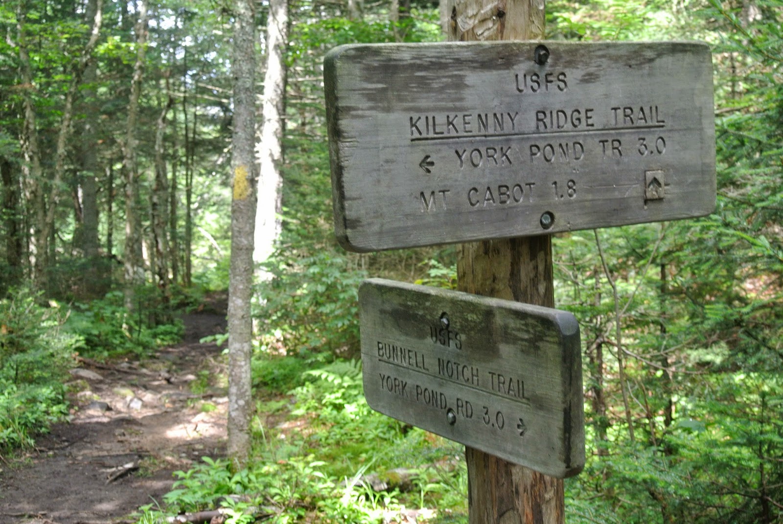
This hike was definitely more technical (read: rocky) than the ones I've been doing this summer.  I also greatly appreciated the clear signs at every juncture. Such as: 

and 


Here's a disclaimer: if you don't like getting your feet wet, literally, then don't do this hike after a rain storm. I gave up having clean, dry feet after a rock wiggled lose in a brook crossing and left me ankle deep in water. The hike actually became more enjoyable after that moment because I just blasted through any minor water/mud, which, again, there was a sufficient amount of. 
Just walk through it. Your shoes will dry. 
Oh, also, at that ski trail juncture there's a nice little look out of more cascading water that I do not suggest you just walk through. 1. It's more rapid. 2. There's no point.

Just for viewing. Not walking in. Unless you want to.
So you continue up because of course that's how you get to Isolation, but it's also the way you get to Glen Boulder and you want to see Glen Boulder. Trust me. Hiker be warned, there is a slight scramble you will have to conquer before you see said boulder. It's fun though! I was reminded of Howard and our climbing buddy yelling at me to trust my feet when I was rock climbing. It's really hard to do when you can't look down and see you're feet though. (Side note: when you come back this way, this doesn't seem like a scramble at all and you'll wonder why there were excited butterflies when you went up, or that's just me.)

Scrambling
Then, when you least expect it (although now you'll be expecting it) you'll see Glen Boulder. It's breathtakingly awesome when you're not expecting it. I guess I should've given you a spoiler alert before saying that part.
See, it's up there! Just follow the cairns!
If you're feeling a little lazy, stop hiking altogether at the boulder. The views will make you smile from ear to ear, kind of like what I'm doing in the picture above. (And clearly, the blue skies won out for the most part.)

Some fog did roll into the valley.


The trail is above tree level for the majority of the time as you weave through the cairns to Slide Peak, aka Gulf Peak. The trail is like a talus field: full of rock jumping. I think you can tell I got distracted by all the beauty and I couldn't help myself from snapping pictures left and right and forward and back.

Up and Up
Blueberries! 
Views for days.
Hang out. Have a snack. 
After a quick snack, continue on until you get to the junction with the Davis Path. Go down the hill, away from Mount Washington if your mission is to get to Mount Isolation. It says it on the sign even, and I'm a very careful reader of signs now a days.

The fog really rolled in at this point, leaving me viewless. I was okay with that because as you go downhill (yes, downhill) it becomes wooded. Oh, and wet again. It was pretty much hiking down in a small, continuously running brook. There's also trees that have been blown over. Looks like the Big Bad Wolf was working overtime.
No worries though. They don't obstruct your path.

In addition, if you were planning on the bridges to help you keep your feet dry you might want to rethink that notion. A lot of them are well loved and have either sunk, become detached, are rotted, or just don't exist
Muddy toes! Of course my shoelaces are untied. Typical.

There's a junction I failed to snap a photo of both times I went by it. If you see it, keep going straight on the Davis Path. I believe the other option is Isolation Trail East which is why I stopped and debated which way for a minute before getting informed by a very nice family that I needed to continue on downhill. Yes, the majority of the hike on Davis Path is downhill. There's some nice flat running parts as well as uphills as you pass Rocky Branch and get closer to Isolation.
It's uphill and flat-ish from here

Luckily, there's a little temporary sign announcing you go up to the right to hit Isolation. The misting had stopped at this point, my shoes were disgustingly muddy and wet, and the views were AWESOME! Except to the North as the fog was still hanging around those darn Presidentials. 


So, now it was time to head back and go UP the Davis Path. This is the part most people are not stoked about when taking this route to Mount Isolation. However, I felt like it was quicker going up than going down this time around (I'm also throwing out raps. I must be tired.) So the nice thing about an out and back is how I know where I am and what's coming up. The bummer about this route is I find it difficult to run down a rocky, boulderish trail. However, I was feeling good when I got to the bottom so it was time to add 4.7 more miles onto the 12 miles I just completed.

I contemplated stopping off at the car and dropping some gear off before cruising up the Wildcat Ridge Trail. I decided not to waste the time and head to the trail. You need to jump over the stone wall that gently guides you to Ellis Glen Falls. Then comes the "brook" crossing. Well, after multiple inches of rain it was more of a white rapids crossing. I made it half way across and found it impossible for the combination of my short legs, wet sneakers, and camera swinging around my neck to make it across. I wasted half an hour on a rock contemplating all my options, looking for different ones, and wishing the water wasn't so high so I could just jump in and walk across. I'm cool with wet sneakers, but that water was rushing and was clearly going to hit me at the hips. I turned around.

I decided I would hang out with all the tourists, otherwise known as 93.2% of the parking lot, and check out Glen Ellis Falls. I was thoroughly impressed, just like with Glen Boulder. It was well worth the flat, .3 mile walk.

So I headed back to my car feeling all warm and fuzzy from the waterfall and boulder, but frustrated that I wouldn't be able to cross off Wildcat D. 

BLESSING IN DISGUISE, MY FRIEND.

Soooo, apparently, when I wear polarized sunglasses and the sun comes out I don't see that the lights are still on in the car. And since my hiking car is older, it also doesn't beep at me saying, "Hey, idiot, you left the lights on!" nor do they shut off automatically. So imagine my surprise, not pleasant for the first time that day, when pressing unlock wouldn't unlock the car. DEAD.AS.A.DOORNAIL. (How cliche.) I swear I should be blonde because at this point I had no idea I had left the lights on and the battery was just dead. 

Did I mention my phone was well on its way to dying as well? AWESOME! The fact that I had to walk down the road for service was just icing on my cupcake. I called the boy (of course!) to ask what procedure to take. He LOVES these phone calls, especially when he's out of the country (that's a different story though) or at a work event (that's this story, and kind of the other one, too). He did me a solid and get me added to his emergency roadside stuff and called a tow, but only after I found a super duper nice couple to try to jump me (didn't work). They also hung around with their car running so I could give my phone some life.

It took over 2.5 hours from trying to unlock the car to getting it jumped. Those roadside assistant guys have a legit system to give your car some power though. That part took two seconds. Afterwards, I didn't want to turn the car off because I was scared it would die (yes, this is my first dead battery! I don't know the rules!) So, I drove straight home instead of running all the errands I had planned in North Conway. That lead to a very hectic Saturday (hunting for a dress for a wedding THAT day). The  car is also still kicking. I actually used to to schlep all my stuff to Vermont from New Hampshire (it was a lot of schlepping). 

And reader, do not fear, I'll be back to the great White Mountains this weekend to check some more peaks off, as well as Labor Day. It shall be my sanity before the school year officially gets underway. 

Until then, happy trails, wading, and getting around.

Ha forgot the stats:

Total milage: 12
Time: a hair under 5 hours
Exertion: moderate
Views: totally worth it 

Friday, August 15, 2014

Middle Carter...My Faith Restored

Monday was gorgeous, so I wrestled with spending the day hiking through the woods or sunning on a beach. Luckily for my 48er quest I had soaked up some rays doing yard work the prior day. I whipped together my hiking gear and headed towards Middle Carter. A peak that I have said, aloud to actual people,  that I was going to conquer that day but have bailed on for a myriad of excuses well developed reasons. Alas, today would be the day, and I was dreading it.

For starters, it was my first hike after the horrendous, life altering, infamous Cabot hike. (I just shuddered. Read prior post if you have no idea what I'm talking about and okay, I have a flair for the melodramatic.) Secondly, it would be my second wooded summit. I mean I hike for the views. I guess I should've started my hiking career with 52 with a view, but whatever.

I parked at the Imp trail that has the sign for the Carter-Moriah Trail. If you're traveling Route 16 North, it'd be the second lot on the side of the road for the Imp Trail. The Imp trail is an actual loop that start and end a few tenths of a mile away from one another.
Park here, or don't. I'm not your boss.
I headed up and my warm hiking fuzzies started to return. I could hear water babbling off to the side. The trail was wide, easy to navigate, and not one ounce of over grown vegetation. The grades were gentle, the ground sprinkled with pine needles, and the soil beneath soft and cushiony like a memory foam rug. I was getting amped for my run back down.

Any down trees were easy to get around.
This screams, "Run me!"

This trail literally has a little something for every hiker. I was pretty jazzed the boy and I bailed on bagging Middle Carter last fall when we did Wildcat A, Carter Dome, and South Carter. Otherwise, I would never had known the awesomeness that is the Imp Trail (well, this side, but that's for later.)

There's gentle grades for the trail runners, waterfalls for the sightseers, a wooden "ladder"/stairs for the ones that like something a little different, views for anyone that is breathing, wooden bridges for those that want a flat surface, and for those who have a love affair with rocks, welllll...rock slabs, rock stairs, dry rocks, wet rocks, rock hopping, rock beds, yadda, yadda. 
I love a nice cascade.
Soon after ohhing and ahhing the cascade and rock stepping over a stream you'll find this gem. 

Don't get too comfortable on the gentle grades. Who needs a stair master when you can hike?

Slabbing further up, past Imp

A river ran through it...

So that's just a taste to wet your hiking chops. Let's go more into depth with the views, shall we? Little did I know (because I'm a horrible researcher...very much let's get the basic idea and then go with it) there's a spectacular view on Imp Face. I mean my eyes were wide and I literally stopped in my tracks for a moment. It totally took away the disdain and general disgust for the snake I saw crossing the trail. Feast your eyes on this.

See, have picnic here. On rocks over looking a huge valley and mountains.
Or just enjoy the views that my camera failed to truly depict.
I was like Ariel when she got her voice back.

The best part about this surprise, giant rocky slab to sit and have a picnic on was how easy it was to get to. I have to say one of the best parts about these adventures is learning about other peaks I otherwise didn't know about. I'm pretty sure Howard is getting tired of me coming home and being like, "We have to go do this again because it was awesome!" I'm pretty sure he'd rather be there the first time, but alas, he has a real grown up person's job and is still recovering from his ACL avulsion.

So from here the trail you keep going along until you come to a crossroads, which I failed to take a picture of for here. Regardless you'll be faced with the decision to go right, leading you down the other side of the Imp trail back to Route 16 or go left, leading you up towards the Carter-Moriah Trail. Whatever your decision, don't go right (again, more on that later).

So you head on up towards the Carter-Moriah Trail on what I guess is technically called the North Carter Trail. This part of the hike is a little more technical with rocks, but nothing traumatic or even remotely close. It's like a wooded hike. It is, or was, quite wet. 
Wet, rocky, nature.

This part of the hike got a little monotonous for me. I think I was also hungry. Seems to happen a lot around mile 3. I should start prepping better for mile 3. I just loathe stopping and taking all my gear off and untangling my straps to grab a snack. I'll move on...

So you go up along the wet stones until you come to your next signage which tells you you can turn around, or go either right or left on the Carter-Moriah Trail. 


If you're like me and looking to head to Middle Carter then go right towards the Zeta Pass. This is where the wooden bridges I mentioned earlier come into play as well. 
Pretty cool looking if you ask me.
This one was my favorite because it unexpectedly opened up and the colors just punch you in the face.

There's even more! I just wanted to give you a sampling. It also makes the last 0.6 miles of your hike enjoyable and not very strenuous. So, you're hiking and you're going to find some rocks. Some, if you have short legs like me or are not very flexible which is starting to happen to me, you'll have to give yourself a gentle hand up or boost to get up. However, wooden bridges are not the only enjoyable part of this leg. 

VIEWS! I'm talking Presidential views, too. There's a viewpoint that has a cairn on it. Stop, take it in, but keep going. That's not the summit, just a nice place to rest. 
Not a summit cairn. 

Not angry about this.

So, I found my lunch spot. I had made these AH-MAZING banana, oatmeal, chocolate chip "cookies" the night before (literally, that's all it is, banana, oatmeal, and chocolate chips) and they filled me up with energy and the knowledge that I was doing something good for my health. Yet, they're so yummy you feel guilty about it. Seriously, bananas are amazing. There's SO MANY things you can do with them that I could write a whole post about it. (And maybe I will!)

Anyway, the point of this hike was to bag Middle Carter. Between the cairn on the slab and the actual summit, try not to fall off the rocks you need to semi-scramble (again, only if you're short or inflexible) as you take in the view. 

Also, hint, there's no longer a sign to announce you're arrival to the summit. There's no pretty cairn saying, "Hey, go you, you made it!" There is this:


It's off on the right side. I was checking my handy-dandy gps, which told me I had already walked by the summit, which made sense because I started to go downhill. So I backtracked and found this and assumed (I'm praying I assumed correctly) that this was the marker. 

I thought, "Cool, cross it off. Let's go run that gorgeous Imp trail." HA. HAHAHAHA. Why do you laugh, you say? Well, again, I like loops so instead of going down the side that I came up, I went down the other side of the Imp Trail. I figured they'd be somewhat alike. I mean, I had such a pleasant experience on the other side. I wouldn't want to miss anything similar. HA! Two words: WET ROCKS! I got fooled. You can't run on wet rocks! (Okay, maybe you can, but I can't.) At one point I stubbed my toe pretty spectacularly. Four days later and it still hurts. I also wiped out on a giant, wet, slabby piece of rock. It was one of those slow motion falls that you feel coming even before it happens. Got some nice scrapes on my elbow and a two inch bruise on my hip. However, I refused to allow it to ruin what was otherwise a surprisingly lovely hike. I have also come to love the predictability of an out and back hike. 

Overall, I would do this hike again. Which says a lot without saying much.

Total distance: 9.9 miles
Total time: 3 hours and 42 minutes (not including my 10 minute lunch break...hey, I was savoring the cookies)
Effort: Easy up, easy/moderate down because you have to concentrate on wet rocks!
Views: Yes, but not on the actual summit (laaaame)

Happy Trails, ya'll!


*I just found out Imp Face is on 52 with a view. No wonder I was impressed. Check another one of those off list as of 8/19

Tuesday, August 12, 2014

Cabot...I Prefer the Cheese

So it's been a bit of time. That's what being swept away to Nantucket will do to a blogger. However, the day before said trip I selected an "easy" hike to cross off my dwindling list. Enter the most northern 4,000 footer: Mount Cabot.

Have ya'll ever had a hike that was just more hassle than you bargained for? First, getting there was a journey in of itself. I left figuring the 9 mile of gradual terrain would have me back at home early enough to complete the copious amounts of laundry that had piled up leaving me not a lot to pack for my trip the following morning, Plus, I knew there was a chance of rain showers in the afternoon (but meteorologists are only accurate 30% of the time so that negates the 30% chance of showers...right?) Back to getting there. I cruised up through Franconia Notch to my 3rd most used exit: Exit 35, straight on through to 115, then 2 East. I really do enjoy the mountain views and historic feel of 115 and 2. I always think, I should stop and take some pictures of that pretty old church, but alas, I never do. I continued on to Berlin and followed Route 110 West until I found the York Pond Rd leading to the fish hatchery. I loved seeing some of the fish breaking the water as I drove by the main entrance. I kept plugging along and pavement soon gave way to dirt and the feeling that I wasn't on the right road. However, great news, I was. You'll see a parking lot on the right that goes to Unknown Pond Trail and a few tenths of a mile up there's a small area to park that will lead you to Bunnell Notch Trail/York Pond Trail. Overall, it was around an hour and half from Lincoln to reach my parking destination.
Trailhead sign along with a free sock

Follow the trail under the gate
The sky was shining blue and I was stoked that there was a sign pointing out the trail because one might not realize it was there just by looking. Two words (well really a compound word so one) describe the first section of this hike: overgrown. At some points the plants were taller than me! Also, I was happy I had decided to wear leggings as there were some pricker bushes in the brush.  You'll also want some bug spray because those suckers (literally) were out with vengeance.


Head right and in to the jungle on the Bunnell Notch Trail 

The trail was fairly flat for the first mile or so. Any uphills were complemented with a follow up flat and these uphills were not anything that would leave you huffing and puffing. The easy grades were also enhanced by the sounds of the cascading brook that ran alongside the trail.


I did notice a variety of berries hanging out along the trail. 


Just a sampling. There were other berries, but I got a little lazy.


Now, here is were I made a big error (well one of like 3 that day). I'm notorious for getting lost at least once a summer on a hike. My most epic error involved friends, which could be one reason I hike solo a lot more. Anyway, I came to a crossroads. There was a sign. A very easy to read sign. See sign below.


See that arrow that says MT CABOT 1.8 go STRAIGHT. Well apparently I was just fascinated with the arrow above it telling you all about York Pond Trail (which is the trail I started on before turning right into the jungle). Soooo, yeah. I went on a nature detour to the semi-viewless Terrance Mountain. I went 2 miles the wrong way! And let me tell you. This trail is populated by one thing: moose poop. I sh*t you not, it was every five feet and yes, that pun was totally intended.

So many piles EVERYWHERE!

I was just waiting to go around a bend and run into one and pee my pants in fear. Not only that, but this trail was eerily quiet. Plus, there was a random saw on the side of the trail. I had visions of bears dragging away the body of the person who was using said saw. I have an overactive imagination sometimes. 

A small lookout from Terrance
This sign made me want to go home ASAP

So there I am, forced to turn around and head back the 2 miles I just covered. As soon as I get back to the crossroads I kick myself for being flighty. I get excited again as I head to Mt. Cabot this time and notice the trail is perfect for some running, so that's what I do to make up time.
Thank you for letting me know I'm going the right way after 0.1 miles. I'm now in need of constant reminders that, yes, this is the right direction.

Trail running ends soon after this section

Unfortunately, it doesn't last long as I start to ascend up and up and my stomach starts growling "feed me!" I tell it to hush up before a bear feeds on me. I trudge on because at this point it's totally a trudge and I just want to be at the summit. I trudged so hard I almost missed the sign for the view from Bunnell Rock. 

Yay! Views!

I should've stopped to ate my lunch/snack here, but I'm stubborn and thought, "Heck, the summit must be right around the corner." I really had no idea because my phone was dying so I stopped my hiking app that tracks my milage. I felt like I was crawling the last mile. I have never been so elated to see a structure that indicates you have made it!
Cabot Summit Cabin

Views from my lunch spot


I've mentioned before that I'm a sucker for a loop trail. I like to see all aspects of a mountain. So I went forth along the Kilkenny Ridge, straight into the woods to take Unknown Pond Trail back. The trail goes down and up, up and down as you go over The Buldge. At one point I scared myself and a big bird that took flight from the middle of the trail. The moose poop returned and I'm pretty sure one had crossed the trail a little prior to my arrival because it smelled like wet dog (not that I know what a moose smells like, but this is my assumption). I didn't even bother going the little bit out of my way to see The Horn because I was exhausted. I didn't even run. I was just trying to hold myself together as I realized my love of loops added on extra mile and a half. Plus, gray clouds started to blot out the sun.

As I came to the junction for Mill Pond Trail and Unknown Pond Trail, I had a moment of "Oh, this is cool. This is why I hike." as I gazed over the lily-pad covered pond.


This is also when I had a moment of "I have to get off this mountain because that sky doesn't look great." It was time to dig deep and run. Run I did. Outrunning the rain though is a tricky thing to do when you're 3 miles deep on another very overgrown trail. As I gazelled down the mountain I saw a moose bed in the plants, felt more prickers attack my ankles, avoided copious amounts of poop, leapt over water crossings, and prayed that the trailhead was near. Then the worst happened. My knee started a dull, okay sharp, ache. I cried. I continued to run: crying, cussing, willing my knee to behave and the trailhead to appear miraculously before me. It was the longest 3 miles down a mountain.

I cried tears of joy as the trailhead opened up before me. I saw how awesome a view it was that I missed on my drive in because I was focused on finding the trailhead. I cursed the rain for ruining my shot and preventing me from hanging out with the fish. All I wanted in that moment was dry clothes (which I didn't have! curses!) and my shoes off my feet. Did I fail to mention how badly my feet hurt? Again, this hike was a calamity of errors on my part and apparently I failed hygiene class and didn't cut my toe nails soon enough. I'm now waiting for my big toe nail to fall off as it's busted in half thanks to Cabot.

In summary I hiked way too many miles to bag this peak, got a zillion and one bug bites, busted a toe nail, got caught in the rain, and saw enough moose poop to last me a lifetime. I wanted to quit hiking for the rest of the summer (good thing I had that getaway to Nantucket the next day!)

I hope ya'll learned a valuable lesson from my careless errors. And no worries, I hiked again...report on Middle Carter to follow soon.

Happy Trails!